Tak fordi du støtter denne side ❤️
Giv en donation
Giv en donation
Gør dig klar til dit næste eventyr:
Som Amazon-partner tjener denne side en kommission på kvalificerede køb uden ekstra omkostninger for dig.
Skovhuse Gade
- Afstand: 8,8 Km
- Højdestigning: 55 m
- Maksimal højde: 87 m
- Højdetab: 67 m
- Minimum højde: 56 m
- Tid i bevægelse: 1 t 23 m
- Hastighed i bevægelse: 6,3 Km/t
- Maksimal hastighed: 23,2 Km/t
- Samlet tid: 1 t 23 m
- Samlet hastighed: 6,3 Km/t
Interaktivt rutekort
Tak fordi du støtter denne side ❤️
Giv en donation
Giv en donation
Gør dig klar til dit næste eventyr:
Som Amazon-partner tjener denne side en kommission på kvalificerede køb uden ekstra omkostninger for dig.
Ruteprofil
- Afstand: 8,8 Km
- Højdestigning: 55 m
- Maksimal højde: 87 m
- Højdetab: 67 m
- Minimum højde: 56 m
- Tid i bevægelse: 1 t 23 m
- Hastighed i bevægelse: 6,3 Km/t
- Maksimal hastighed: 23,2 Km/t
- Samlet tid: 1 t 23 m
- Samlet hastighed: 6,3 Km/t
Tak fordi du støtter denne side ❤️
Giv en donation
Giv en donation
Gør dig klar til dit næste eventyr:
Som Amazon-partner tjener denne side en kommission på kvalificerede køb uden ekstra omkostninger for dig.
Om denne rute
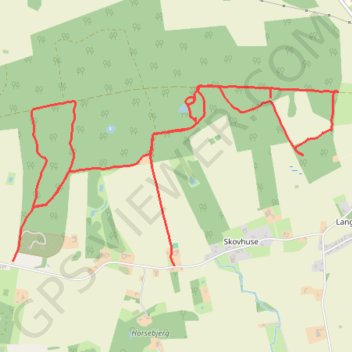
Navn: Skovhuse Gade rute, afstand, højde, kort, profil, GPS-spor
Koordinater: 55.00462 12.03779 55.01599 12.07359
Tak fordi du støtter denne side ❤️
Giv en donation
Giv en donation
Gør dig klar til dit næste eventyr:
Som Amazon-partner tjener denne side en kommission på kvalificerede køb uden ekstra omkostninger for dig.